 |
| Home | News | Calendar | Cottage | Caving | Events | Members |
The South Wales Caving Club Expedition to The Franche Comte(The Jura and the Doubs)23rd July to 6th August 2005Franche-Comté is the name given to the vast area of woodland which lies to the north of the French Alps in Eastern France, and stretches southward along the Swiss border for 250km, from Vosges to the Jura. The region is divided into four different départements, the Haute-Saône, Doubs, Jura and Territoire de Belfort, the first three of which all contain important cave systems. The Franche-Comte is brimming with sites of outstanding natural beauty, including Alpine meadows, lakes, cirques, waterfalls, thick forest and some of the most beautiful rivers in France. Glaciation, high rainfall and copious Spring snowmelt has encouraged plentiful erosion on the predominant Jurassic limestone landscape, resulting in a full range of karst features, including of course, several thousand cave systems. Where is it?...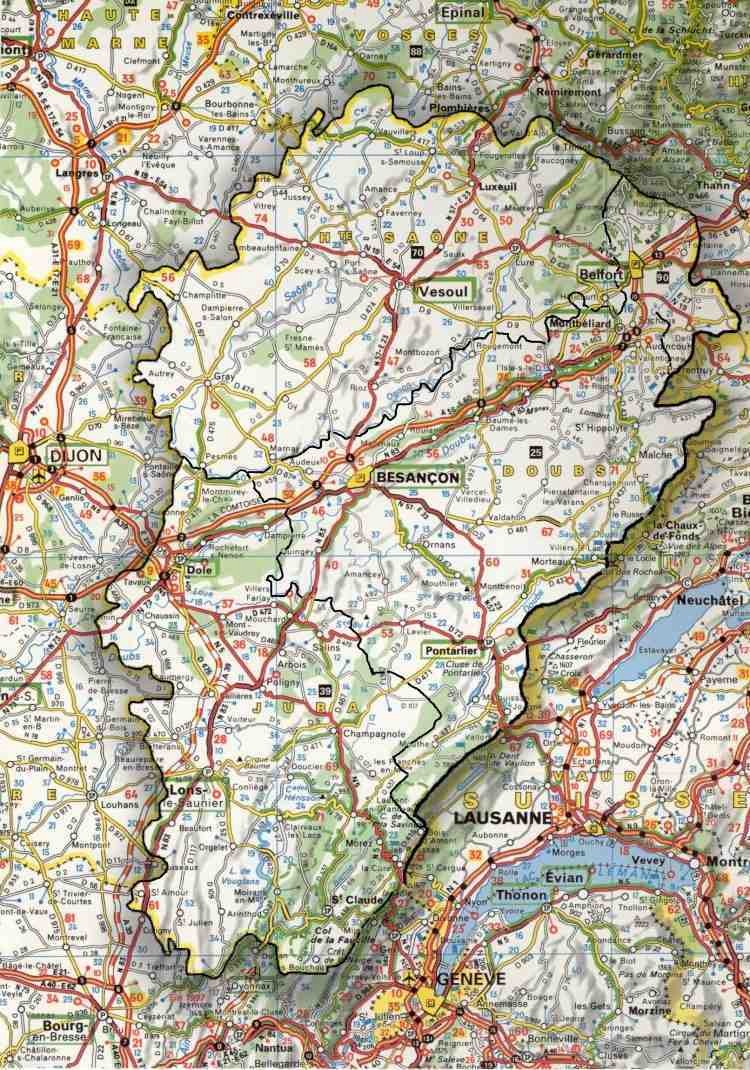 As you can probably appreciate from the map extract, the area is quite a large one. It nestles up against the Franco Swiss border immediately east of Dijon. We will be based roughly in the middle in a picturesque little town called Ornans which is located on the D67 about 20km south of Besancon. The area is probably best reached using the Dover – Calais or Folkstone – Calais crossings. A route is available which cuts south east around Reims and Dijon which negates the need to get tangled up with Paris. An alternative more elongated route swings up into Belgium and down across Luxembourg to drop back into France at Nancy. The auto routes are all free of toll on this route but it does take a little longer. A little about the local geology…………….The region can be divided into three major zones, the Mountains, the Plateau Ridges and the Lowlands. The mountains are located in the east and follow a NE-SW axis along the Swiss border. They are quite small mountains for the area, the highest peak being Cret de la Neige, at 1718m high. A few Alpine style shaft systems can be explored in this zone. Parallel with the mountains lies an extensive series of Plateau Ridges, which range in height from 900m to 400m, stepping down gradually from East to West. These gently undulating agricultural regions, are home to the majority of the caves (including most of the major systems), particularly around the spectacular river gorges separating the ridges. The final region, the lowlands, occupies the north of the region, but includes only a few notable caves, formed in isolated ridges. The waters drain North-West from the eastern mountains to the Saone valley. To get there they have to cross the plateau ridges, for which there are only two possible options, via Cluses (narrow gorges cutting through the ridges) or via caves, which is why the majority of cave systems are found within the Plateau Ridges region. The whole region has been subject to quite severe folding and faulting, and this has had a powerful effect on cave development. Underground drainage is predominantly directed along the axis of the folds. Since the dip is generally shallow, underground streams can travel very large distances and the separation from sinks to resurgence can be considerable (the longest positive trace is from Seignes de Passonfontaine to Source du Maine, a distance of 28km over a vertical range of nearly 500m). However, the narrow widths of the synclinal folds acts as a limit on overall catchment areas and consequently many major systems consist of single streamways, albeit of great length. The resurgences are often large and impressive, but almost invariably flooded for a considerable distance. The feeders to these Collecteurs are predominantly vertical, simple shaft systems, of not very great depth (commonly between 100m and 300m). Most peter out in mud chokes and impenetrable cracks, but a few utilise tectonic fractures to connect directly into the Collecteurs. There are probably many more of these, hidden beneath a blanket of alluvium. A third type of cave passage is found in ancient, fossil remnants, located in the higher beds. Due to the relative youth of the Jurassic formation, these are quite scarce, but typically feature large, dry tunnels, often adorned with huge, muddy formations. So what are the caves like?……………..The caves of the Franche-Comte are generally simple in plan, with a series of vertical Dales like pots feeding long, linear streamways. This is partly due to the geology and partly due to the relative youth of the Jurassic formations. The caves are commonly wet, muddy and well-decorated, often with large formations. Jurassic limestone can be thinly-bedded and brittle, so care should be taken when climbing or traversing. The weather is generally sunny, but punctuated by sudden and severe thunderstorms. This can create real problems, for the water tends to flash through the caves very quickly. Pitch heads should be rigged as far out of potential flood water as possible and long trips into streamways are best timed to avoid the late afternoons. The vast majority of caves in the Franche-Comte are prone to flooding of one degree or another, so it is best to take some food and survival kit on most trips. On the plus side, the water is likely to drop as fast as it rises, so a few hours wait will normally allow for a safe exit. Choice of personal kit can also be difficult. Many of the dry caves can be very warm, requiring only the lightest of clothing. On the other hand, the wet caves often require full wetsuits. Over 5000 caves have been mapped, the majority of which are horizontal systems. Approximately 100 caves exceed 1km, 50 exceed 2km, and no less than 15 exceed 5km in length. No very deep caves exist, but of the vertical systems, three exceed 300m in vertical range, and more than 50 exceed 100m. The region is equally famous for cave diving and includes some of the most extensive submerged networks in Europe. Here is a short list of the sort of thing available………..
Camping...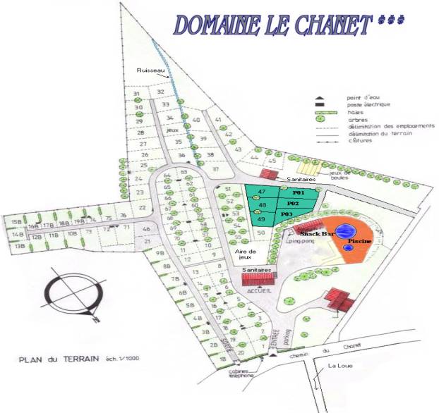 The campsite is booked! We have reserved 8 pitches in the area of the site that projects out to the west ( look for 14B on the map). Mr Clipstone kindly carried out a reconnaissance of the site and informs us that these are the best ones with a good deal of shade and nice flat pitches. The site itself had been recommended by several well respected cavers and to boot it turns out that the Wessex mega trip this year ( 50 plus attendees ) used the same site. The url for the site is http://www.lechanet.com/ . It seems to be a very tidy site with loads of amenities including ‘Le Snack Bar’ and of course La Piscine. Camping on the site gives you complimentary access to the Piscine Municipal which is a few hundred metres up the road. Money, Money Money……… Until we get a better idea of numbers we have only reserved 8 pitches. We are working on the basis that people may want to share pitches and hence reduce the cost. If you would like to reserve a complete pitch then would you be so good as to forward a cheque for Ł40.00. If you would like to share a pitch would you please forward a cheque for Ł20.00. Cheques should be made payable to ‘Cantabria Expeditions’ Pitches will obviously go on a first come first served basis. If numbers require further pitch reservations I will make these reservations as and when it becomes obvious that we need them. I’m not guaranteeing that we will get more pitches but it sounds like the area where the Wessex camped ( northernmost triangle ) is pretty open plan and although quite steep and devoid of shade will probably accommodate last minute bookings. One or two of the families have booked the mobil home accommodation available on the site ( no prizes for guessing who! ). If you would like to reserve one of these do let me know or speak to the campsite direct. Any further questions answered free of charge on 01202 743632 or thesydney AT btinternet.com or gary AT dorsetland.co.uk Gary Vaughan, The Sydney, 6 Frankland Crescent, Poole, Dorset BH14 9PX |